
Arteaga
"Saltillo is desert. Then the road climbs and the temperature drops and there are apple trees. Mexico surprises me with this kind of shift more than anywhere I've lived."
Saltillo sits on a high plateau at 1,600 meters surrounded by semi-desert — agave, creosote, pale caliche soil, the blue-gray shapes of distant sierras. It’s a proper northern Mexican city: big, industrial, not particularly interested in being picturesque. I had been there for two days sorting out a bureaucratic matter that I don’t need to get into, and on the morning of the third day I rented a car and drove east toward the Sierra Madre.
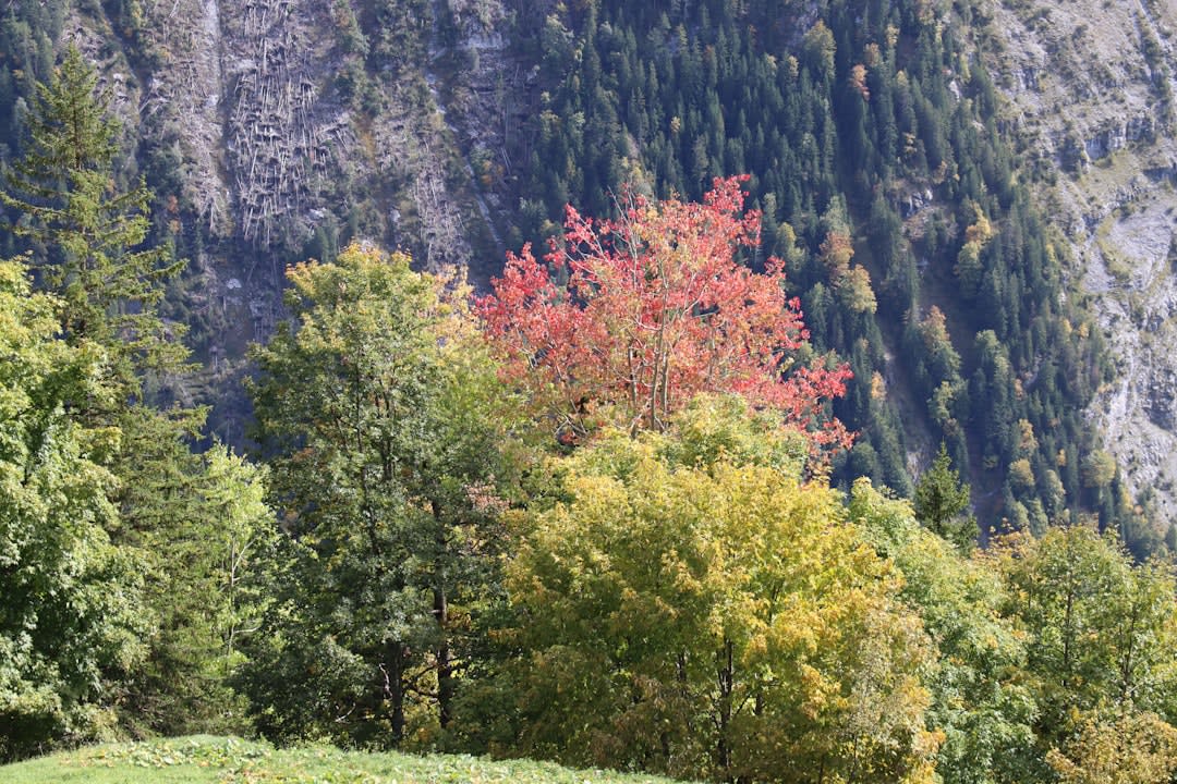
The landscape change is quick and it is dramatic. The highway climbs from the plateau into the sierra in a series of switchbacks, and the temperature on the dashboard display drops as you go — Saltillo at 18 degrees, the climb at 14, the crest of the range at 10. On the other side, the Cañón de Arteaga opens below you: a limestone canyon with terraced orchards visible on the slopes, a river thread at the bottom, the road descending in curves through a landscape that does not look like Coahuila at all.
The Canyon Road
The road down into the canyon is the experience. It’s a two-lane mountain road with switchbacks that require genuine attention but are not technically difficult — the kind of driving that is actually pleasurable if you are not in a hurry, which you shouldn’t be, because the view changes every two hundred meters and the apple trees alongside the road are the reason you came.
In November, when I drove it, the trees had turned. “Turned” sounds simple but the apple trees of Arteaga in late autumn go through a range from pale yellow to burnt orange to the specific deep amber of a good brandy, and they do this on the terraces cut into the limestone slopes in a way that stacks the colors vertically up the hillside. I had to pull over twice just to sit with it. I am from Normandy originally, a region of apple orchards that I find beautiful, and these orchards in their limestone canyon were different but not lesser. The comparison pleased me more than it probably should have.
Roadside stands appear at intervals along the descent — family operations selling cider, apple jam, dried fruit, and the local fresh cheeses. I stopped at one where an older man was working alone. The cider was sold in plastic liter bottles, unlabeled, and he charged twenty-five pesos. I bought two. The cider was dry and slightly fermented, not quite alcoholic but trending that way, with the specific taste of wild apples that apple cider in France occasionally has when it comes from old heritage orchards rather than commercial production.
The Town and the Cheeses
The town of Arteaga itself is a small market town at the base of the canyon — a grid of streets, a central plaza, the usual church and municipal building, a market where the agricultural products of the canyon are sold alongside the general goods of any small Mexican town. It doesn’t try to be a destination in the way that some mountain towns in Mexico try to be destinations. The orchards are the business.
The cheeses sold here and in the canyon are worth specific attention. The Sierra Madre of Coahuila and Nuevo León has a dairy tradition — the cool climate and the grass pastures produce good milk — and the local cheeses are made in the direct, unelaborated style of northern Mexican cheesemaking: fresh white cheeses, slightly salty, with a dense texture that holds together when you slice it. A vendor at the Arteaga market had three varieties on a table, and when I asked to taste one she gave me portions of all three without waiting to be asked again. The second one, a slightly aged variety with a firmer paste, was the best cheese I ate in Coahuila.
I ate it at a picnic table near the market with the cider I had bought on the way down. A dog appeared and sat next to the table with the patience of long experience. I gave it a piece of cheese. The dog reconsidered its position on the bench and moved closer.
The Canyon Bottom
The road continues from Arteaga town into the lower canyon, where the river runs between walls of pale limestone and the pine forest becomes denser. There are swimming holes accessible from the road in summer; in November they were cold and clear and deserted. I walked to one of them along a path that followed the river bank for about twenty minutes, through undergrowth and river-polished stones, and found a clear pool with the cold water running over white gravel.
I did not swim. The air temperature had dropped to 8 degrees by this point and the idea of submerging in glacier-temperature water seemed medically inadvisable. I sat at the edge of the pool for a while. A pair of ducks came through. The silence was the kind that exists when there are no roads or people within earshot and only the river and the wind in the pines.

Getting There
Arteaga is about 50 kilometers east of Saltillo — roughly an hour’s drive, plus however long you spend on the canyon road. Car is the only practical way to experience the canyon itself; there are buses to Arteaga town but they don’t stop at the canyon viewpoints. Saltillo is well connected by bus and domestic flight from other Mexican cities. The best time to visit for autumn color is late October through November; the apple harvest season runs from August through October and the roadside stands are fully stocked. Summer is pleasant in the canyon when the rest of Coahuila is very hot.