
Huaynamota
"When your two options are a questionable dirt track along a cliff edge or a boat through a canyon the colour of rust and shadow, and both feel worth it, you stop second-guessing and just go."
I took the boat. Not because the road looked impossible — it probably wasn’t, with a capable truck and the right attitude about drop-offs — but because the San Pedro Mezquital river was right there and two hours inside the Barrancas del Nayar felt like the more honest introduction to a place that takes some convincing to reach. The canyon walls came up rust-orange and shadow-green, shades I hadn’t seen stacked quite like that before. By the time we rounded the last bend and Huaynamota appeared on its flat river terrace, I had forgotten every plan I had made for the following week.
The Canyon That Contains It
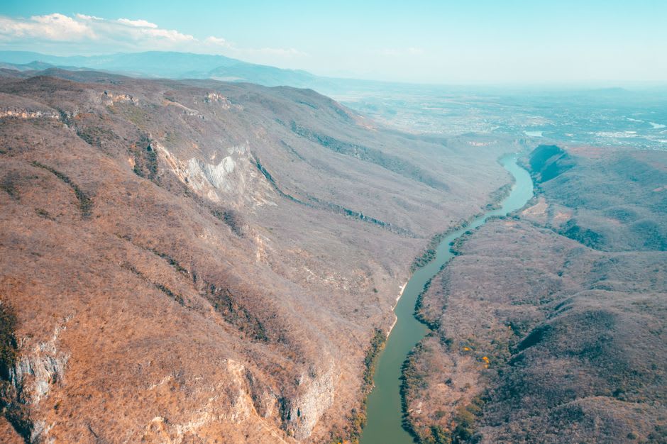
The Barrancas del Nayar is why Huaynamota is Huaynamota. The canyon system cutting through the Sierra Madre Occidental here is immense — wider and deeper than most visitors expect, with walls that shift color hour by hour as the sun moves across the upper rim. The San Pedro Mezquital runs green-brown through the bottom of it, a river that in rainy season turns the color of café de olla and rises fast enough to close access for days at a stretch.
If you come by road from Jesús María, the track descends along cliff faces where the asphalt gave up years ago and corrugated dirt demands patience and high clearance. I’ve spoken with people who drove it in three hours without incident and others who turned back at the first serious switchback. The river route from El Naranjo avoids all of that: a lancha, a boatman who knows every submerged rock by feel, and two hours of watching the canyon open and close around you before the village finally appears. There is no bad way to arrive. There is only the slow way and the slower way.
Cora Country
The Cora — Náayeri in their own language — have lived in these barrancas since before anyone started counting. They resisted Spanish colonization longer than almost any group in western Mexico, and the canyon geography made that possible: the Barrancas were effectively ungovernable from the outside. That history is not abstract here. Huaynamota runs on Cora time, Cora logic, Cora priorities. There is a small church, a basketball court, a tienda selling refresco and basic provisions, and a population entirely accustomed to outsiders arriving confused about what they expected to find.
The village is not set up for tourism, which is not a complaint. It means that being there requires a different register — quieter, slower, without agenda. A few families host travelers informally; food tends to be whatever is available, usually frijoles, tortillas, eggs, occasionally fresh river fish fried in a pan with enough oil. I had some of the best black beans of my time in Mexico sitting on a plastic chair watching the current go by. The bar for contentment drops considerably when the canyon walls are that high above you.
The Hot Springs at River Level
The thermal springs are why most people make the journey who aren’t specifically there to visit Cora communities. They emerge from the rock face near the water’s edge — warm enough to feel deliberate, not so hot as to be theatrical — and the contrast with the cool river makes the whole arrangement feel almost engineered. I spent a morning moving between the two, watching a pair of herons work the shallows on the opposite bank, doing nothing in particular. That is the correct activity.
There is no infrastructure around the springs. No changing rooms, no posted hours, no entrance fee. Bring what you need and leave before dark.
Getting There
The nearest city of any size is Tepic, roughly three hours northwest. From Jesús María, negotiate with your vehicle before committing to the canyon road — high clearance is not optional. For the lancha route, El Naranjo is the standard departure point; arrange a boat in advance, as schedules are informal at best. Dry season, November through April, is when access is most reliable. Rainy season can close both routes without warning and without apology.