Volcán de Colima
"The volcano was producing a steady column of steam from the summit. A bird sang somewhere below me in the pines. I stood very still."
The Volcán de Fuego de Colima has been erupting, in various degrees of seriousness, since at least 1576, when Spanish colonial records first documented it. In 2015 it produced one of its largest eruptions in a century, a column of ash that rose twenty kilometers and forced evacuations in a thirty-kilometer radius. Since then it has continued doing what it does: emitting gas and steam more or less constantly, producing periodic ash plumes, occasionally sending lava down its flanks. CENAPRED, the national disaster center, maintains a monitoring station and issues regular bulletins. The access restrictions around the upper volcano fluctuate with activity levels.
I mention the 2015 eruption not to alarm anyone but to establish the baseline of what we are dealing with. This is a genuinely active stratovolcano in a populated state, and the Colimenses who live in its shadow have a relationship with it that is more practical than fearful — they have evacuation plans, they watch the alerts, they live their lives. The volcano is visible from Colima City, from the coast at Manzanillo on clear days, reportedly from Guadalajara when the conditions are right. It is the dominant physical fact of the state.
The Drive Up
The Parque Nacional Volcán de Colima encompasses both the active Volcán de Fuego and its dormant twin, Nevado de Colima — the higher peak to the north, snowcapped in winter, the one that the climbing routes go up when conditions allow. The park entrance is accessible from the town of Ciudad Guzmán in Jalisco to the north, and there are routes from the Colima side as well, though road conditions and closures depend on volcanic activity and should be checked before driving up.
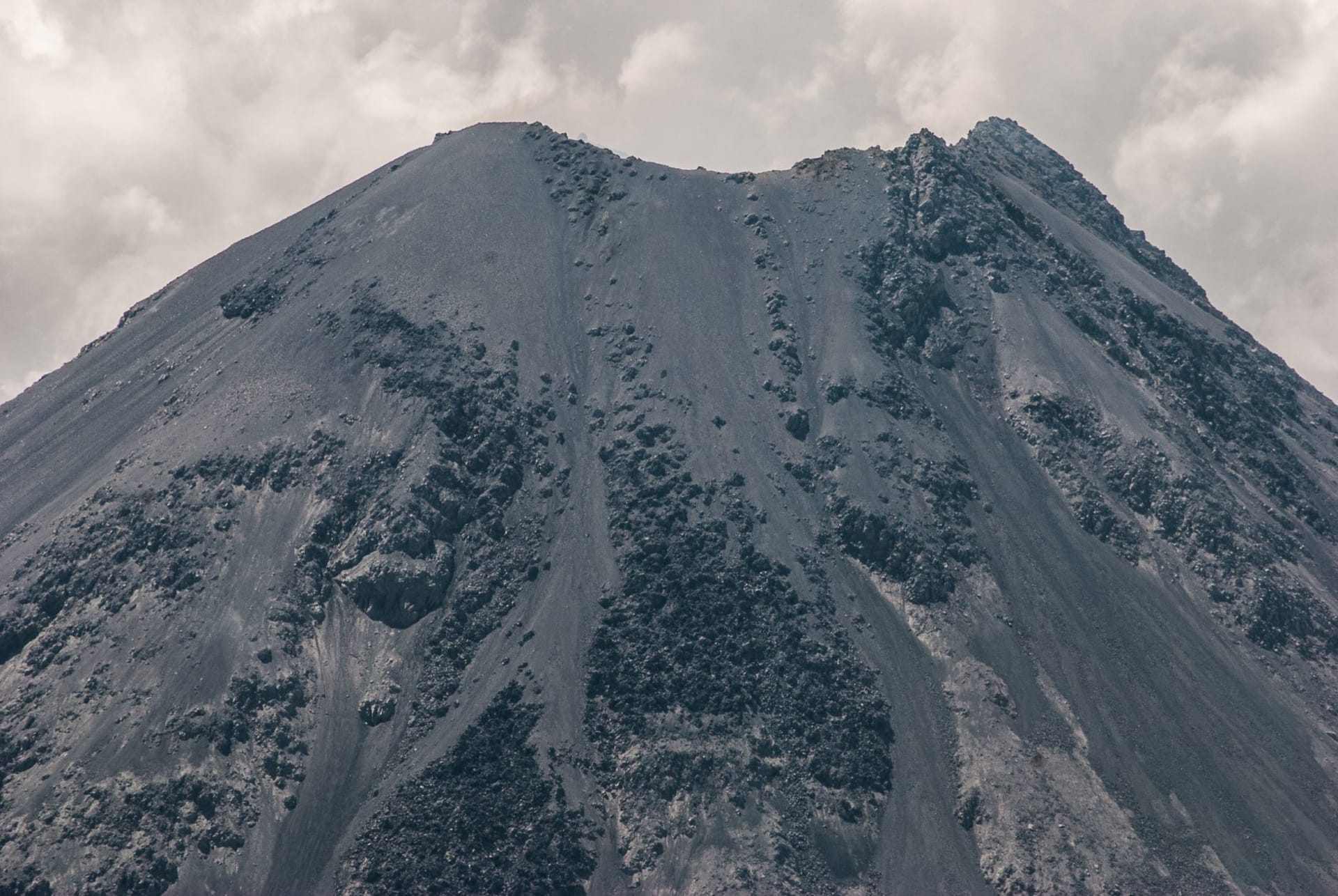
I went on a clear January morning from Colima City, a forty-minute drive to the lower entrance of the park. The road climbs through farmland — corn, sugarcane — and then into pine-oak forest that densifies as you gain elevation. By the time I reached the park entry point, the air was noticeably cooler and the light had the quality I associate with high altitude: sharp, direct, without the softening haze of the lowlands. Nevado de Colima was visible to the north, pale with snow on the upper slopes. The Fuego, the active cone, was to the south-southeast, and I could see its summit producing a white plume that drifted northeast in the wind.
The activity level that day was rated at “yellow” on the CENAPRED scale — elevated but not emergency. The park personnel at the entrance gave me a map of the accessible areas and were clear about where the boundary was. I did not test the boundary.

What It Is Like to Stand There
I walked a trail through the pine forest for perhaps an hour before finding a clearing that offered an open view of the Fuego. I sat on a log. The summit was clear against the sky — no cloud, just the volcanic plume, white and vertical before the wind caught it and pushed it east. At this distance, perhaps eight or ten kilometers from the summit, the plume looked peaceful. I knew enough to understand that peaceful is relative.
The forest around me was doing normal forest things. There were birds — I heard at least three species I couldn’t identify, including something with a descending call that I have not been able to match to any recording since. There was wind in the upper canopy. There was a small gray squirrel that appeared on a fallen log five meters away and looked at me with the focused assessment of an animal deciding whether I was dangerous, decided I wasn’t, and moved on.
The French comparison that occurred to me, unbidden, was the Auvergne — the Massif Central, the Chaîne des Puys with its line of extinct volcanic cones. But those volcanoes have been extinct for ten thousand years, and the hiking trails around them have wooden handrails at the steep parts. The Volcán de Fuego erupted in 2015. The CENAPRED bulletin I had checked that morning reported “continuous degassing.” These are not equivalent experiences of volcanic landscape.
This is not a criticism of the Auvergne. It is an observation that some landscapes have more ongoing negotiations with their geology than others.
Nevado de Colima and the Climbing Route
The dormant neighbor, Nevado de Colima, is the higher peak at 4,339 meters and is accessible for climbing when the activity of the Fuego is at an appropriate level — the route goes through the park, and closures on one often affect access to the other. The climb to Nevado’s summit is technically straightforward but requires acclimatization; it is a strenuous day hike from the park entry points, not a technical climb. In winter the upper section crosses snow and the views on a clear day extend to the Pacific coast.
I did not climb Nevado on this trip. The smoke from the Fuego was making me thoughtful about what the park service considered “appropriate conditions,” and I settled for a morning on the lower slopes, which was more than enough.

Practical Notes
Check CENAPRED’s volcanic activity reports before visiting — the website is cenapred.unam.mx and the bulletins are updated regularly. Access to the park can be restricted at any time with very little notice when activity increases, and this is not a bureaucratic inconvenience; it is the correct response to an active volcano. Accommodation is available in Colima City and in Ciudad Guzmán on the Jalisco side; there are a few rustic options closer to the park. The best months for clear summit views are November through March.