Quilotoa
"The color of the lake is wrong in the best possible way — it reads as digital until you're standing at the rim."
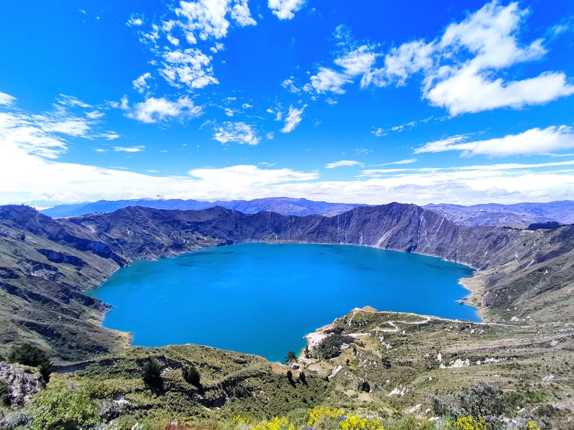
I’d seen photographs of the Quilotoa crater lake. I thought I understood what I was going to see. I was wrong about this in the way you’re always wrong about photographs of water — they flatten the color, they can’t convey the depth or the wind or the sense of standing on the edge of something that has collapsed spectacularly and is now quietly beautiful because of it. The lake is turquoise-green, sulfur-mineral, impossibly still when there’s no wind, and about three hundred meters below the crater rim. It looks like someone has placed a piece of malachite inside a volcano and covered it with a lid of sky.
The Quilotoa Loop
The village of Quilotoa is the endpoint, but the Quilotoa Loop is the thing. The four-day trek from Sigchos (or the shorter two-day version from Isinliví) passes through a sequence of indigenous Kichwa communities in the high-altitude farmland west of Latacunga. These are real working villages — potatoes terraced into every available slope, women in woven skirts moving along paths with loads that would floor most hikers, eucalyptus planted as windbreaks on the ridgelines.
The scenery is relentlessly dramatic in the understated way of the Ecuadorian highlands: deep quebradas (ravines) dropping below the path, distant volcano cones visible on clear days, and the trail itself sometimes nothing more than a strip of mud between agricultural plots. I did two days of it, staying one night in Isinliví, and it was the best two days of my time in Ecuador.
The Crater Rim and the Descent
From the village of Quilotoa, the crater rim is a fifteen-minute walk. The first view hits you like a wall. The lake sits so far below and so still that you have to confirm to yourself it’s real water and not painted ground. The rim walk is about eight to ten kilometers and takes most of a morning, with viewpoints that keep revealing new angles on the caldera.
The descent to the lake is steep and loose — down to a small black-sand beach where kayaks are available for rent. I went down. Coming back up at altitude, with no wind to cool you and the sun bouncing off volcanic rock, is one of those experiences where you spend most of the effort regretting the decision and then immediately feel it was worth it once you reach the rim.
Staying in the Village
The village of Quilotoa is tiny and geared almost entirely toward trekkers, with a handful of basic hostels clustered near the crater entrance. I stayed at one with wool blankets and a wood stove and ate whatever the woman running the kitchen was cooking — quinoa soup, potato stew, rice with a fried egg — for a few dollars. The cold at night was serious. The stars, in the absence of any light pollution, were the kind you forget about when you live in cities.
When to go: The dry season from June through September is the best window for the loop trek, with clearer days and more reliable trail conditions. December through February can also be reasonable. The morning light on the crater lake is at its best in the first hour after sunrise, before any haze builds. Avoid March, April, and May when trails turn to mud and the crater is frequently shrouded in cloud.