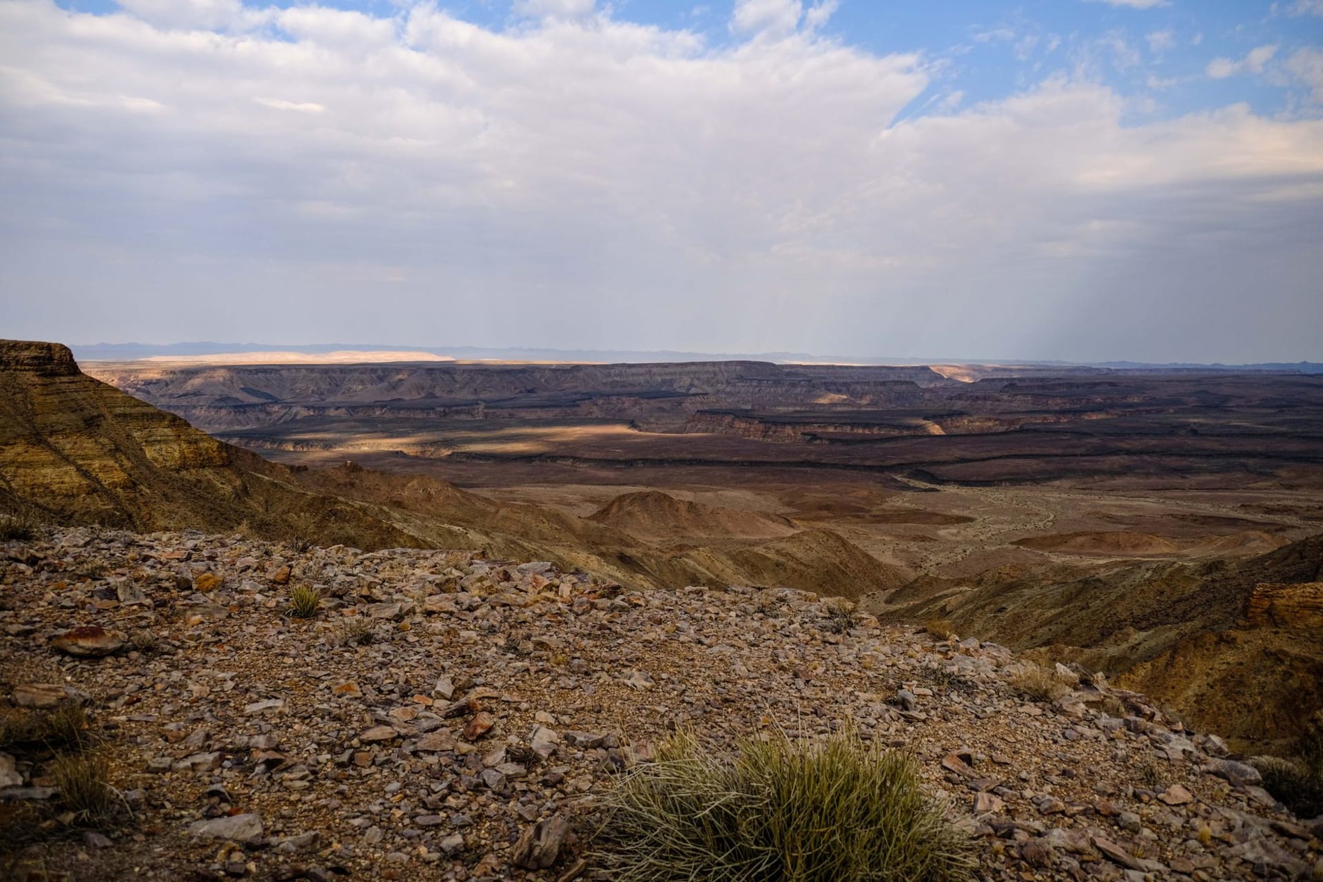
How Big Is It, Actually
I drove to Fish River Canyon from the south, up through the !Ai-!Ais hot springs resort, and the canyon just appeared — no build-up, no interpretive signage counting down the distance, just a sudden absence of ground. The main viewpoint sits at the canyon’s widest section: 27 kilometers across, 550 meters deep, 161 kilometers long. Those numbers don’t mean anything until you’re standing at the edge watching a Cape vulture circle below you.
The Fish River stopped being a full-time river long ago. What’s left is a series of pools and a broad sandy wash that meanders through the canyon bottom — you can see it from the rim as a thin green-grey line threading between cliff walls that look like they were painted with ochre and rust. The geology here is serious: the canyon cuts through some of the oldest exposed rock formations in the world, Precambrian basement gneiss that has been sitting here in various forms for half a billion years.
The Rim vs. the Canyon Floor
Most visitors do what I did the first morning: drive between the half-dozen official viewpoints along the western rim, photograph the canyon from progressively different angles, and leave. That’s fine. The light at dawn and dusk is extraordinary — the canyon walls turn amber then deep red, and the shadows fill the gorge bottom like poured ink.
But the serious business here is the five-day hiking trail that descends to the canyon floor and follows the river south to !Ai-!Ais. It runs 85 kilometers and is only open from May through September, when the temperatures in the canyon bottom don’t reach 45°C. I met a group of four emerging at the end of their hike at the hot springs — they smelled like the desert itself, salt-crusted and sun-baked, and had the specific satisfied expression of people who have just done something genuinely hard. The waiting list is months long in good years.
South to !Ai-!Ais
The hot springs resort at the southern end of the canyon has the peculiar charm of a place that exists primarily for tired hikers and German retirees who’ve come to soak their joints in 60°C mineral water. The pools are genuinely therapeutic and genuinely hot. After two days of driving on corrugated gravel roads, I was grateful for both.
The drive up from the South African border through the southern Namib is worth treating as its own thing rather than just access road. The landscape is almost completely without vegetation — pale gravel plains stretching to low mountains, the odd gemsbok standing in the middle distance looking unimpressed by the heat. Quiver trees appear occasionally, their spiky silhouettes the closest thing to visual punctuation for a hundred kilometers.
Getting There Without a Guide
The canyon is accessible independently, which is part of why it rewards people willing to make the effort. The C10/C37 gravel roads are manageable in a normal sedan in dry conditions, though the corrugations will rattle your fillings loose if you go too fast. Fill up on fuel in Keetmanshoop — there’s nothing reliable between there and the canyon. The NamibRand reserve and Lüderitz make logical extensions if you’re in the region.
When to go: May through September for hiking and for tolerable temperatures in the canyon. The trail is closed October through April due to flash flood risk and lethal heat at the bottom. Rim viewpoints are accessible year-round, and the emptiness of June and early July — before the main European summer holiday rush — gives you the vultures and the silence entirely to yourself.