Pueblo Nuevo / Mexiquillo
"Three hours in the Mexiquillo fog and I saw perhaps six other people. The rock formations appeared and disappeared as the mist shifted. I stopped checking my phone."
I drove up from Durango City on a gray November morning, which turns out to be the right kind of morning for this particular landscape. The road climbs from the Durango plateau into the Sierra Madre Occidental — first through dry scrubland that turns gradually into oak, then into pine, then into the dense mixed fir and pine forest of the high sierra. The logging trucks come down this road loaded and go up empty, and for much of the climb you share the switchbacks with them, which focuses the attention.
Pueblo Nuevo sits at around 2,400 meters and is a working logging town. There are lumber yards and men in work clothes and pickup trucks and a central plaza that serves the functions a central plaza serves without performing anything for visitors. I stopped for coffee and a quesadilla at a small place near the market and continued.
Mexiquillo: The Landscape That Shouldn’t Be Here
The Mexiquillo protected area is a 20-minute drive from Pueblo Nuevo on a road that deteriorates gradually but remains passable. I parked at a small trailhead with a hand-painted sign and what appeared to be a self-pay box that had recently been vandalized, and walked in.
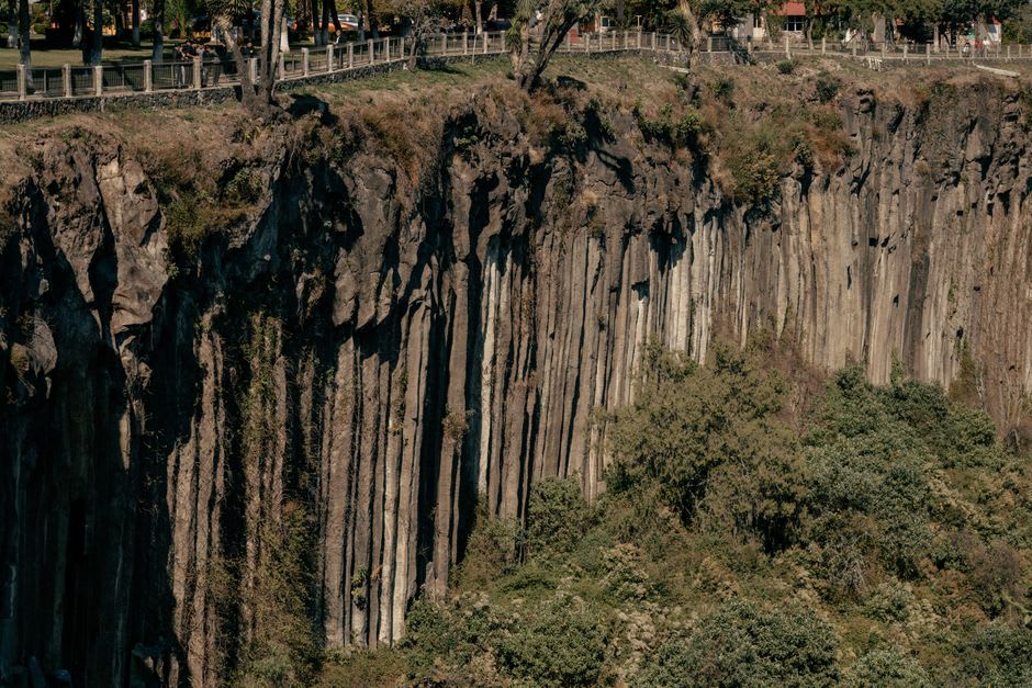
The rock formations emerge from the forest without warning. One moment you’re in a dense stand of fir trees with lichen on the bark and the smell of cold pine resin, and the next there’s a basalt column six meters tall standing in a small clearing. Then another. Then an arch you can walk under, and beyond it a balanced boulder the size of a small car resting on a narrow pedestal in a way that ignores the normal assumptions you carry about gravity.
The formations are volcanic — the Sierra Madre Occidental is geologically complex in this stretch, and the basalt intrusions have been weathered into shapes that look designed. Some of them look like the work of a sculptor who was given too much material and not enough constraint. The European comparison that kept occurring to me was the Chaos de Montpellier-le-Vieux in the Aveyron, the dolomite landscape in southern France where the weathered rocks form a kind of natural city. Mexiquillo is not identical — the rock type is different, the forest is different, the scale is different — but the quality of strangeness is similar.
Three Hours of Near-Silence
I spent three hours walking the main trail and several unmarked paths branching off it. The mist came in and went out every twenty minutes or so, and when it came in the visibility dropped to thirty or forty meters and the rocks at the edge of the clearing went gray and uncertain and then vanished entirely. When it lifted, the whole landscape sharpened back into focus in a way that made the rocks look newly placed each time.
I saw six people in three hours. Two were a couple who arrived, took photographs for fifteen minutes, and left. The other four were a family from Durango who had clearly been here before — they moved through the formations with the comfort of people returning to a familiar place, not discovering one, which was somehow reassuring.
The trails are not maintained in a way that implies serious infrastructure, which means you need reasonable footwear and some attention to route-finding, but nothing here is technically demanding. The challenge is the altitude — Mexiquillo sits above 2,500 meters — and if you’ve come directly from sea level, walking uphill between the formations will remind you of that.
Getting There and What to Bring
Mexiquillo requires a car. There is no public transport from Durango to Pueblo Nuevo on a schedule that makes a day trip practical, and the Mexiquillo trailhead has no services.
The drive from Durango is about an hour and fifteen minutes. Take the road toward Mazatlán and watch for the Pueblo Nuevo turnoff. From Pueblo Nuevo, follow signs for Mexiquillo — they exist, though intermittently.
Bring water, something warm, and food you don’t need to cook. There is a small food stall sometimes operating near the trailhead on weekends, and nothing else. Go in the morning if you want the mist; go in the afternoon if you want the light. Going both mornings of a two-night Durango stay is not an unreasonable plan.