
Ruteng
"I came to Ruteng for one strange field and stayed for the cold mornings and the coffee that comes with them."
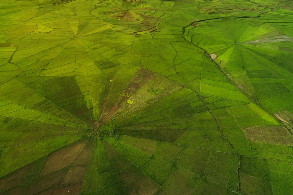
A highland market town wrapped in cloud and volcanic ridgelines, where the fields around it are still cut into giant spiderweb shapes that only make sense from above.
Ruteng sits at around 1,200 meters in the highlands of central Flores, and the altitude announces itself immediately — after weeks of coastal Indonesia’s relentless humidity, I actually reached for a fleece in the evenings, which felt like a small betrayal of everything I thought I knew about this country. The town is the capital of Manggarai Regency, and it wears its highland identity plainly: the air smells of woodsmoke and clove cigarettes, the markets sell fat sacks of arabica beans grown on the surrounding slopes, and the churches — spired, whitewashed, unmistakably the legacy of Dutch and Portuguese Catholic missions — outnumber mosques by a wide margin.
The spiderweb fields of Cancar
The reason most travelers detour up here is Cancar, a village about 17 kilometers south of Ruteng, where the Manggarai people still divide communal farmland using a system called lodok — concentric rings radiating from a central point, carved by hand into hillsides so that from above the fields look exactly like spiderwebs. It’s not decoration; it’s an ancient and remarkably fair way of allocating land, with plot size determined by a family’s standing and needs, the whole pattern anchored to a sacred central pole. I climbed the viewpoint hill above Cancar at sunrise, breath fogging, and watched the light come up slowly over dozens of these webs stitched across the valley floor. A farmer already out working his wedge of the pattern didn’t even look up.
Wae Rebo, and the town that guards it
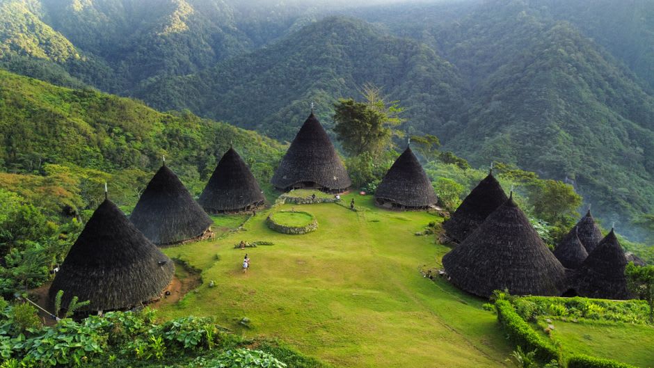
Ruteng is also the jumping-off point for Wae Rebo, the cluster of seven cone-shaped mbaru niang houses tucked into a remote mountain valley that UNESCO recognized with a Heritage Award in 2012. The trek in — a few hours through cloud forest from the trailhead village of Denge — is arguably Flores’s single best hike, but it’s Ruteng that supplies the permits, the guides, and the last real meal before you disappear into the hills. I spent a night in Ruteng both before and after the trek, and the second night felt entirely different: I’d earned the plate of jagung titi (pounded, flattened corn, a Manggarai staple) I ate at a warung near the market, in a way I wouldn’t have appreciated on the way in.
Ruteng itself doesn’t try hard to charm you — it’s a working highland town, with a busy central market, motorbikes hauling coffee sacks, and a chill that keeps everyone moving briskly. But there’s a version of Flores here that the beach towns don’t show you: agricultural, Catholic, cool-aired, and organized around land in ways that predate every road that now connects it to the coast.
When to go: May to September, dry season, for clear views of the Cancar spiderweb fields and passable trekking conditions to Wae Rebo. Nights are genuinely cold at this elevation year-round, so pack a layer regardless of when you go.