Columbia River Gorge
"Skip Multnomah Falls and hike to Angels Rest. The view from above the clouds is an entirely different conversation."
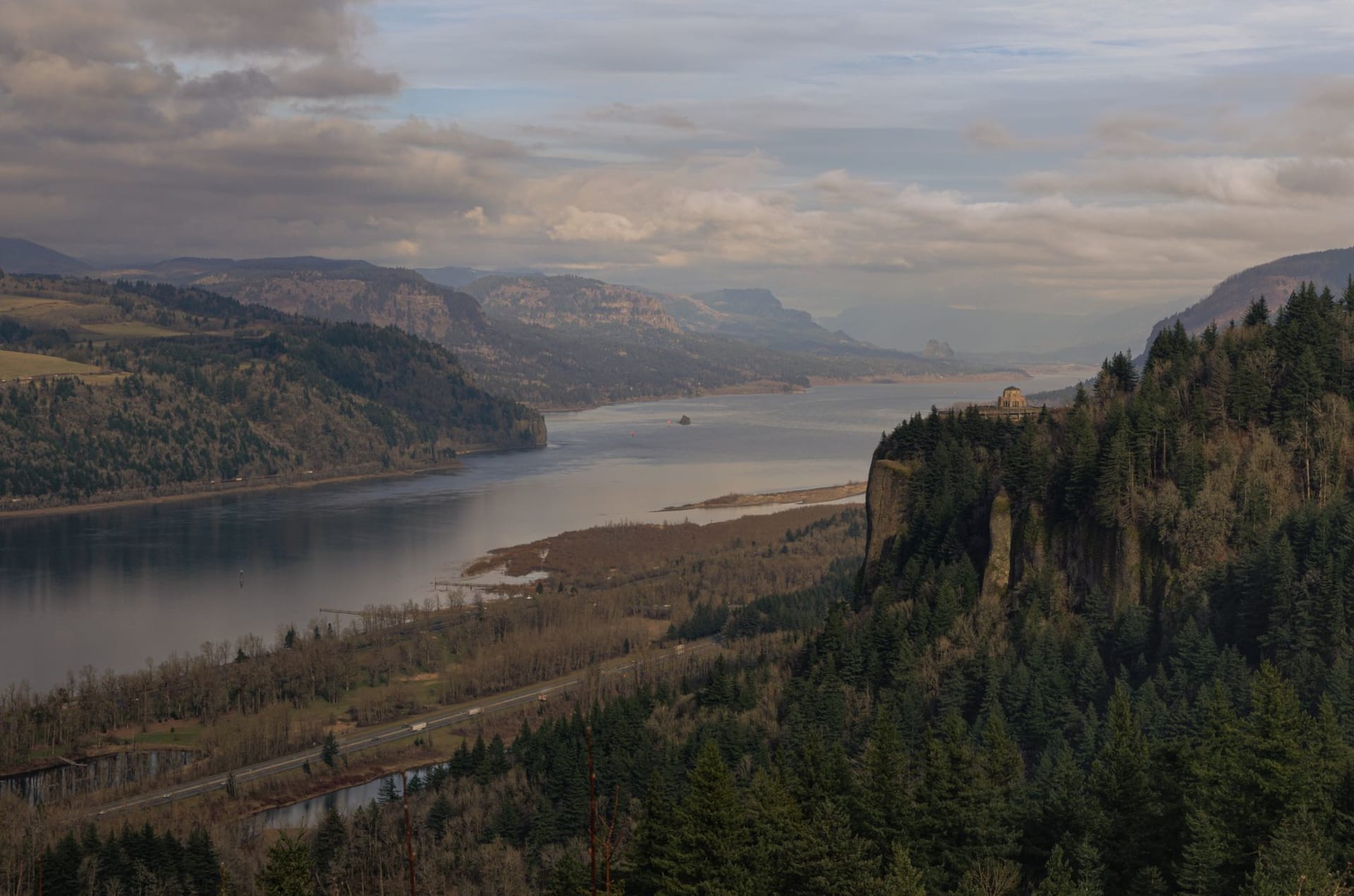
The Columbia River Gorge starts about forty-five minutes east of Portland and changes the scale of everything. You’re in the suburbs one minute — strip malls, traffic lights, the particular tedium of outer ring-road America — and then the basalt walls appear on either side of the river and the sky narrows and you realize you’ve driven into something that was carved by a different order of force entirely. The Columbia cuts through the Cascades in a gorge that was shaped by the Missoula Floods at the end of the last ice age — catastrophic floods that moved more water in a matter of days than the Amazon does in a year. The walls you’re looking at are what remained.
I’ve driven the Historic Columbia River Highway — the old road, built in the 1910s, that contours the Oregon side — more times than I can count now, and it rewards slow attention. The road was engineered by Samuel Lancaster to maximize scenery, which means it curves where a modern highway wouldn’t, pauses where a modern highway wouldn’t, offers the kind of deliberate revelation that efficient infrastructure specifically avoids. Vista House, a round stone rotunda on Crown Point, sits six hundred meters above the river on a headland and offers the view that everyone uses to explain the gorge to people who haven’t seen it.
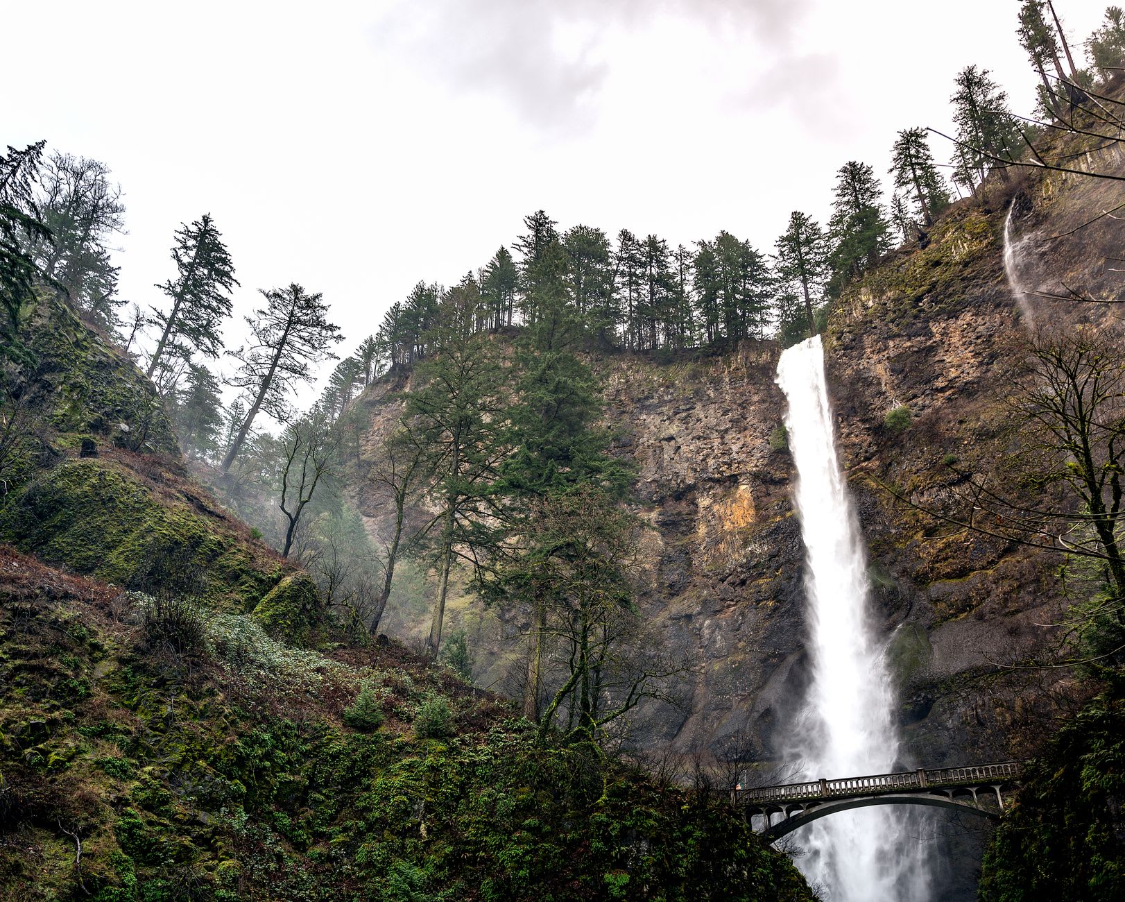
Multnomah Falls gets the crowds and deserves them, but barely — the falls themselves are extraordinary, a two-tiered drop of nearly two hundred meters through a hanging valley, the basalt face perpetually wet and fern-covered. The problem is the paved walkway and the gift shop and the fact that on a July Saturday it’s shoulder-to-shoulder from the parking lot to the bridge. What I do instead: I park at the trailhead for Angels Rest, a four-mile round trip that climbs through Douglas fir and Oregon oak to a basalt outcropping above the tree line. On the right morning — when the valley is in cloud and the summit is above it — you stand on the rock and look west toward Portland over a layer of white cloud with the basalt walls of the gorge cutting through it and the river somewhere below, invisible. It doesn’t feel like Oregon. It feels like nowhere I can name.
The eastern end of the gorge is drier, transitions from the wet westside forest to sage and bunch grass and wind. Hood River, the main town at the gorge’s eastern reach, has become a kiteboarding capital because the gorge funnels wind from the coast with remarkable consistency — on summer afternoons the river churns white and the sky above it is full of kites. It’s worth stopping for fruit: the Hood River Valley is orchard country, and in September the roadside stands have pears and apples and cider fresh-pressed that morning.

The waterfalls along the Historic Highway trail — Latourell, Bridal Veil, Wahkeena, Horsetail — each have their character. Latourell is my preference: a single clean drop of sixty meters over a concave basalt cliff, the rock columned and strange, a short trail to the base where the spray reaches you before you can see the falls properly.
When to go: April through June for the highest waterfalls and the greenest light — the winter rains have charged every stream. September is excellent for hiking without the summer crowds. The wildflowers on the east side gorge trails in April and May are worth the trip on their own. Winter can be icy on the Historic Highway but strangely beautiful — the frozen seeps and icicles on the basalt walls are worth the extra caution.